Topic: Water Cycles
Water Cycles
Compared to a well-sorted sample of larger-sized particles, a well-sorted sample of smaller-sized particles has greater
(1) capillarity
(2) transpiration
(3) permeability
(4) porosity
Which graph shows the general relationship between soil particle size and the capillarity of the soil?

(1) 1
(2) 2
(3) 3
(4) 4
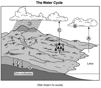
Which process is represented by letter F?
(1) capillarity
(2) infiltration
(3) condensation
(4) vaporization
During a rainstorm, when soil becomes saturated, the amount of infiltration
(1) decreases and runoff decreases
(2) decreases and runoff increases
(3) increases and runoff decreases
(4) increases and runoff increases
In which environment is the amount of transpiration usually the greatest?
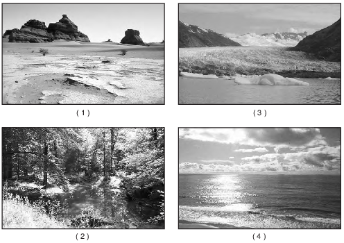
(1) 1
(2) 2
(3) 3
(4) 4

Which statement best explains why 18,000 years ago the coastline was at a different location than it is today?
(1) The climate of Earth was extremely hot and dry.
(2) A large amount of Earth’s water was stored in large continental ice sheets.
(3) The east coast of North America was being subducted under the Eurasian Plate.
(4) North America had just separated from Africa, and the Atlantic Ocean was forming.
The diagram below represents cross sections of equal-size beakers A, B, and C filled with beads.
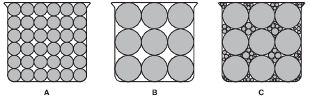
Which statement best compares the porosity in the three beakers?
(1) Beaker A and beaker B have the same porosity, and beaker C has the least porosity.
(2) Beaker A and beaker B have the same porosity, and beaker C has the greatest porosity.
(3) Beaker B has the greatest porosity, beaker A has less porosity, and beaker C has the least porosity.
(4) Beaker C has the greatest porosity, beaker B has less porosity, and beaker A has the least porosity.
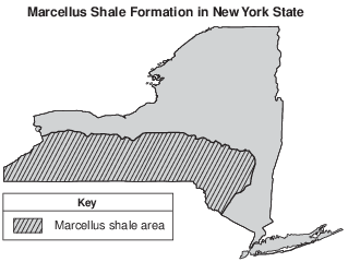
The Marcellus Shale
The Marcellus shale is a black shale formation that was formed during the Middle Devonian Period. The shale extends from New York State as far south as Alabama. The Marcellus shale is exposed at the surface in the northern Finger Lakes region, and is buried 2.1 kilometers below the surface along the New York-Pennsylvania border.
Geologists estimate that the Marcellus shale contains hundreds of trillions of cubic feet of natural gas. Most of the Marcellus shale does not allow fluids (gases and liquids) to flow through the rock. In order to obtain the natural gas trapped in the rock, the shale is fractured. This hydraulic fracturing consists of drilling a well, then pumping in large amounts of water containing chemicals and sand under high pressure to create cracks in the gas-bearing rock. Although this process can allow the trapped gas to be removed from the shale, opponents of hydraulic fracturing argue that the chemicals used in the process may lead to groundwater contamination.
The reading passage states, “Most of the Marcellus shale does not allow fluids (gases and liquids) to flow through the rock.” This statement suggests that the Marcellus shale is
(1) clastic
(2) coarse grained
(3) porous
(4) impermeable
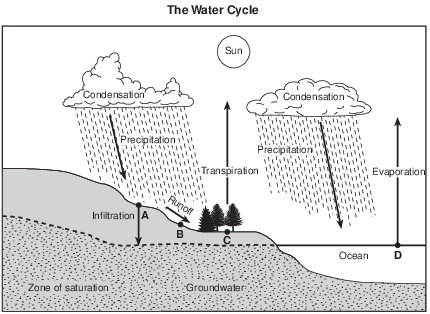
What would most likely reduce the amount of runoff at location B?
(1) infiltration occurring faster than precipitation
(2) greater condensation than evaporation
(3) saturated soil below the land surface
(4) a frozen land surface
The diagram below represents two columns, A and B, that were used to determine the infiltration rate and water retention of two different particle sizes by pouring equal amounts of water through each column.
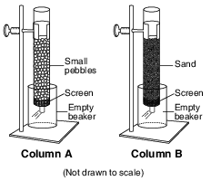
Compared to column A, column B had a
(1) lower rate of infiltration and retained less water
(2) lower rate of infiltration and retained more water
(3) higher rate of infiltration and retained less water
(4) higher rate of infiltration and retained more water
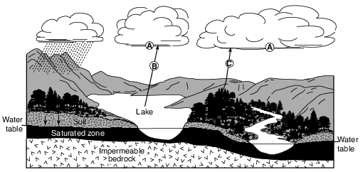
Which condition normally lowers the water table?
(1) irrigation of fields for several weeks, using well water
(2) several days of moderate rainfall
(3) streambanks overflowing during spring runoff
(4) several days of heavy snowfall, followed by rain
Identify the names of the two different processes, represented by letters B and C, that return moisture to the atmosphere. [1]
B: ________________________________ and C: _________________________________
Allow 1 credit for both processes: evaporation or vaporization at letter B and transpiration or evapotranspiration at letter C.
Frozen Mammoth
A wooly mammoth was found in 1999 buried in the frozen soil of the Siberian tundra. Carbon-14 dating indicated that it had died about 20,000 years ago. Many fossils represent only the partial remains of organisms. However, a complete mammoth with bones, skin, hair, and internal organs intact represented a unique opportunity for scientists to investigate the lifestyle of this animal and the environment in which it lived.
The low permeability of the tundra soil helped to preserve the mammoth. Explain why the tundra soil has a low permeability. [1]
Allow 1 credit. Acceptable responses include, but are not limited to:
• — The rate at which water infiltrates the soil will decrease if the soil is frozen.
• — Frozen ground is mostly impermeable.
• — Ice fills the pore spaces.
• — The ground is frozen.
• — The soil is composed of small particles.
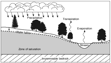
State the relationship between the amount of precipitation in this area and the height of the water table above the impermeable bedrock. [1]
Allow 1 credit. Acceptable responses include, but are not limited to:
• — When precipitation increases, the water table will rise (or get closer to the surface).
• — The level of the water table above the bedrock will increase with greater precipitation.
• — Less precipitation will cause a lower water table.
• — There is a direct relationship between the amount of precipitation and the height of the
• water table above the impermeable bedrock.
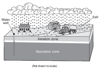
Place an X on the block diagram in the image provided to indicate the location of the water table. [1]

Allow 1 credit if the center of the X is within or touches the clear area that separates the Saturation zone from the Aeration zone.
• Note: Allow credit if a symbol other than an X is used.
• It is recommended that an overlay of the same scale as the student answer booklet be used to ensure reliability in rating.
•